
WEST END NOURISHMENT PROJECT
Please provide comments and questions to the following email: westend@townofdauphinisland.org
The Town of Dauphin Island has secured funding for the West End Beach and Dune Restoration Project. This project is designed to widen the beach, strengthen dune protection, defend town infrastructure, and reduce erosion risks. This project was identified as a priority in the US Army Corps of Engineers (USACE) Final Alabama Barrier Island Restoration Assessment Report, 2020. If this project is not completed, erosion will persist, and the beach, which has been steadily eroding for decades, is unlikely to recover naturally. To create an engineered beach under the Alabama Beach Act, the project has established a designated mean high tide line (MHTL). The designated MHTL establishes the separation between private and public property in perpetuity – even if more erosion occurs in the future. Without this project, Dauphin Island will continue to lose land to the Gulf of Mexico. An engineered beach constructed through the Beach Act will also allow the Town of Dauphin Island to seek additional funding through FEMA. The Town will hold responsibility of maintaining the renourished beach. Engineered beaches in Alabama already exist in Gulf Shores and Orange Beach, as well as now along the East End of Dauphin Island.
Construction and Monitoring Easements
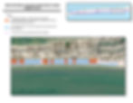
The Town is seeking to obtain easements for the properties shown on the map provided below. These easements allow the Town to place sand on private property at no cost to the property owner. The easement area is limited and generally extends from the southern boundary of the property to approximately the +5-foot elevation contour, or to existing structures such as porches, pilings, or similar features. The easement authorizes the Town to construct and maintain improvements that enhance shoreline protection and support the long-term value and stability of the property.
If a property owner chooses not to sign the easement, sand will not be placed on that property. The project will proceed seaward of the property line, and the lot will not receive the same beach improvements. In that case, existing conditions between the structure and the start of the project would remain unchanged. This could result in a low area that retains water, which would need to be addressed by the property owner at their discretion and expense.
The easement also allows the Town limited periodic access for monitoring and maintenance activities, such as surveying and minor maintenance work. These activities are limited in scope and are necessary to support the long-term success of the project.
The attached map identifies the properties for which the Town is requesting easements. Property owners should have received an easement package at the mailing address listed in the tax records. If you have not received an easement package, please email westend@townofdauphinisland.org.
All the associated information is in hard copy is at the Town Hall and can be viewed there.
NOTICE OF JOINT PUBLIC MEETING
PERMIT APPLICATIONS:
Facts:
-
The project will bring sand to the Island where it is physically most needed based on 100-year trends; this sand will not come back naturally.
-
The project will add 200 acres of public beach habitat that can be accessed in exactly the same way it is accessed today (e.g. permit parking, west end beach parking, walking)
-
The project will protect the Town’s infrastructure (e.g. roads, water and sewer), reducing the costly removal of sand and repair of utilities. Repair costs (e.g. removing sand off of Bienville Blvd) borne by the Town continue to increase on an annual basis due in part to the degradation of the shoreline and dune system in this area.
-
This project will adhere to state and Federal law; minimize impacts to the citizens of Dauphin Island; reduce economic burden on the Town for emergency response; meet requirements for public funding; ensure the Town is qualified for public funds in the future; and maximize short- and long-term benefits for the citizens of Dauphin Island.
-
The Town has secured funding to construct the project.
-
Completing a beach nourishment project requires several interconnected yet distinct steps to comply with permitting regulations and funding requirements:
-
Permits - The required USACE, ADEM, and Alabama Beach Project Act permits have been issued
-
POA Construction Easement has been recorded
-
Construction Easements with Private Landholders - The Town will also continue obtaining necessary construction and monitoring easements from affected property owners from May 2026 through December 2026.
-
Construction Funding Secured for full project
-
Final Design to be completed Fall 2026 based on funding availability
-
Bidding to be conducted in Fall 2026
-
Construction to commence Winter 2027

Describe your image

Describe your image
Describe your image
Describe your image
Maps - West to East - click to enlarge
Updated Maps with house numbers and cross streets.


